Kalaloch Campground
ForestedOlympic National Park · Washington, USA · 20 m elevation · Check-in 12:00 PM · Check-out 11:00 AM
Ocean-bluff camping on Olympic's wild coast, famous for sunsets over the Pacific.
Shade reality: Coastal spruce forest shades most loops; bluff-edge sites trade shade for Pacific sunset views.
Individual sites · 151 mapped
Shade ratings come from Recreation.gov site records. Click any dot on the map for site details; zoom in to see site numbers.
Shadiest sites on 2026-08-02 (least direct sun)
Precomputed estimate for the 15th of this month — all 151 sites, terrain + tree canopy (ETH 10 m, 2020) included.
Find a site
Official campground map160 sites
Cross-check site numbers against the park's own map before you book.
Six loops with per-loop numbering: A1–A69 (ocean-bluff loop — book here for sunset views), B1–B19, C1–C21, D1–D39, E1–E12, F1–F10. No hookups. Several bluff-edge sites in A/D/E are permanently closed due to erosion.
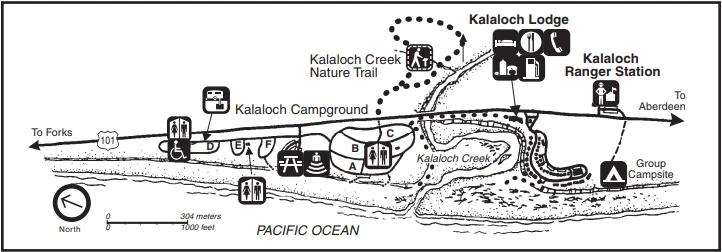
Source: official park map. Compare the loop layout with the satellite view above — north on the official map may not point up.